
Roman Cities Had to Work
A Roman city was only as good as its daily use.
Straight roads helped, but they were not enough. Water had to drain. Carts had to move. Markets needed traffic. Gates had to control entry. The forum had to sit where people actually passed through.
The grid mattered. The system mattered more.
Good Reading
City by David Macaulay
A smart visual book for understanding how Roman city systems fit together: roads, water, forums, housing, walls, and daily life.
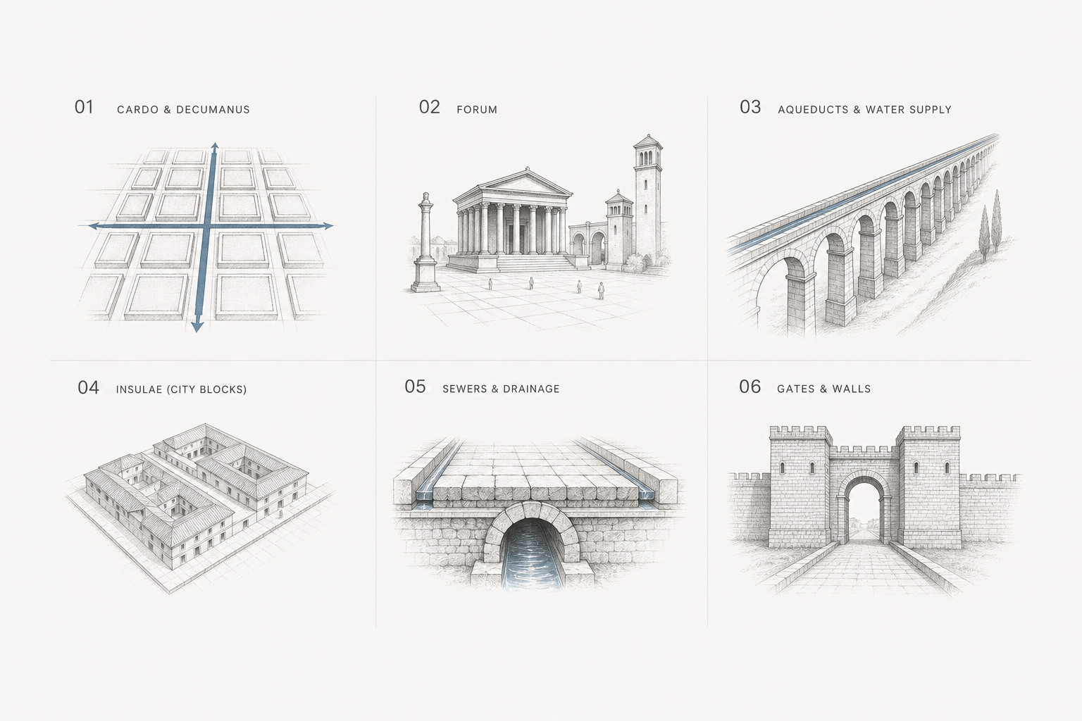
Illustration by ArchitectureCourses.org. Roman urban planning worked as a connected system of streets, public space, water supply, gates, and drainage rather than a collection of separate monuments.
The Grid Was Only the Starting Point
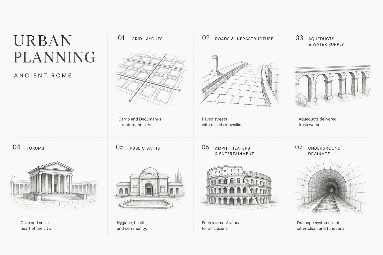
Illustration by ArchitectureCourses.org. Roman urban planning combined street grids, public spaces, water systems, entertainment buildings, baths, and drainage into one working city system.
A planned Roman city usually began with two main streets:
Cardo Maximus: the main north-south street.
Decumanus Maximus: the main east-west street.
They often crossed near the forum. Smaller streets then divided the city into blocks, or insulae.
“Grid” can make Roman planning sound too clean. A grid is just geometry. The real question is what it connects.
The streets had to feed the forum, markets, gates, baths, housing, drains, and water system. If they did not, the plan could look organized and still work badly.
What the Main Streets Did

Illustration by ArchitectureCourses.org. Roman main streets organized movement, blocks, public space, water, and drainage.
The cardo and decumanus did more than divide the city neatly. They made the city readable. A person could move from gate to forum, from market to bathhouse, without guessing where the main routes were.
In Pompeii, the street details are more useful than the grand statements. Raised sidewalks kept pedestrians out of the mess. Stepping stones helped people cross wet or dirty streets. Wheel ruts show where carts repeated the same paths for years. Drainage channels remind you that a street was also a water detail. A street was not just a line on a city plan. It was a surface, a drain, a route, a commercial edge, and sometimes a problem.
| Planning Element | What It Did | Why It Mattered |
|---|---|---|
| Cardo and Decumanus | Created the main street axes | Gave the city a clear movement structure |
| Forum | Held civic, legal, market, and political life | Made public life visible and central |
| Insulae | Divided the city into blocks | Organized housing, shops, and services |
| Aqueducts and fountains | Brought clean water into the city | Supported hygiene, baths, and daily use |
| Sewers and drainage | Moved wastewater and stormwater away | Reduced flooding, filth, and street failure |
| Gates and walls | Controlled access and defense | Linked planning to security and authority |
Roman Planning Terms

| Term | Meaning |
|---|---|
| Cardo | Main north-south street |
| Decumanus | Main east-west street |
| Forum | Main civic square — law, trade, politics, and ceremony |
| Insula | City block, or the multi-story apartment buildings within it |
| Thermae | Public baths tied to water, heating, drainage, and civic life |
The Forum Had to Be in the Right Place

Illustration by ArchitectureCourses.org. The forum was not just a plaza. It sat where movement converged, making civic, legal, and market life visible and central to the city.
The forum was where power showed itself. Law, trade, politics, religion, speeches, records, and public ceremony all gathered there. If you wanted to understand the city, you looked at the forum and what surrounded it.
Placement mattered. A forum needed access from the main streets. It needed enough space for crowds. It needed architectural edges: basilicas, porticoes, markets, temples, and government buildings.
A forum placed badly would weaken the whole plan. People would still move through the city, but the civic center would not pull the city together.
Related: Roman Forum Architecture
Water Was the Hard Part

Illustration by ArchitectureCourses.org. Roman planning depended on water as much as roads: aqueducts brought supply in, fountains and baths used it, and drains carried wastewater and stormwater out.
Clean water had to reach fountains, baths, and sometimes private buildings. Wastewater and stormwater had to leave. Low points had to be managed. Streets needed drainage. Baths needed steady supply. Public fountains needed to sit where people actually passed.
This is where the city either worked or started to rot.
Aqueducts get the attention because they are spectacular. But the quieter parts matter just as much: gradients, channels, drains, outlets, maintenance access, and the placement of public fountains. Water is unforgiving. If the slope is wrong, the system does not care how good the architecture looks.
Baths Were Infrastructure
Bathhouses are often described as social spaces. They were, but that is too soft.
They were also urban infrastructure. They needed water supply, heating, drainage, circulation, crowd control, and maintenance. A bath complex was not just a place to wash. It was a large public building tied into the city's technical systems.
Baths show comfort, hygiene, engineering, status, and public life in one place.
Housing Was Dense and Unequal
The word insula can mean a city block, but it is also used for apartment buildings in Roman cities. That overlap is useful.
Roman cities had to house many people in limited space. Wealthier residents might live in a domus. Many ordinary urban residents lived in multi-story apartment buildings, often with shops or workshops nearby.
This was not a perfect urban dream. Density brought fire risk, noise, crowding, bad living conditions, and uneven access to comfort. Roman planning managed these pressures. It did not erase them.
Good planning can organize a city without making it fair.
Defense Was Built Into the Layout
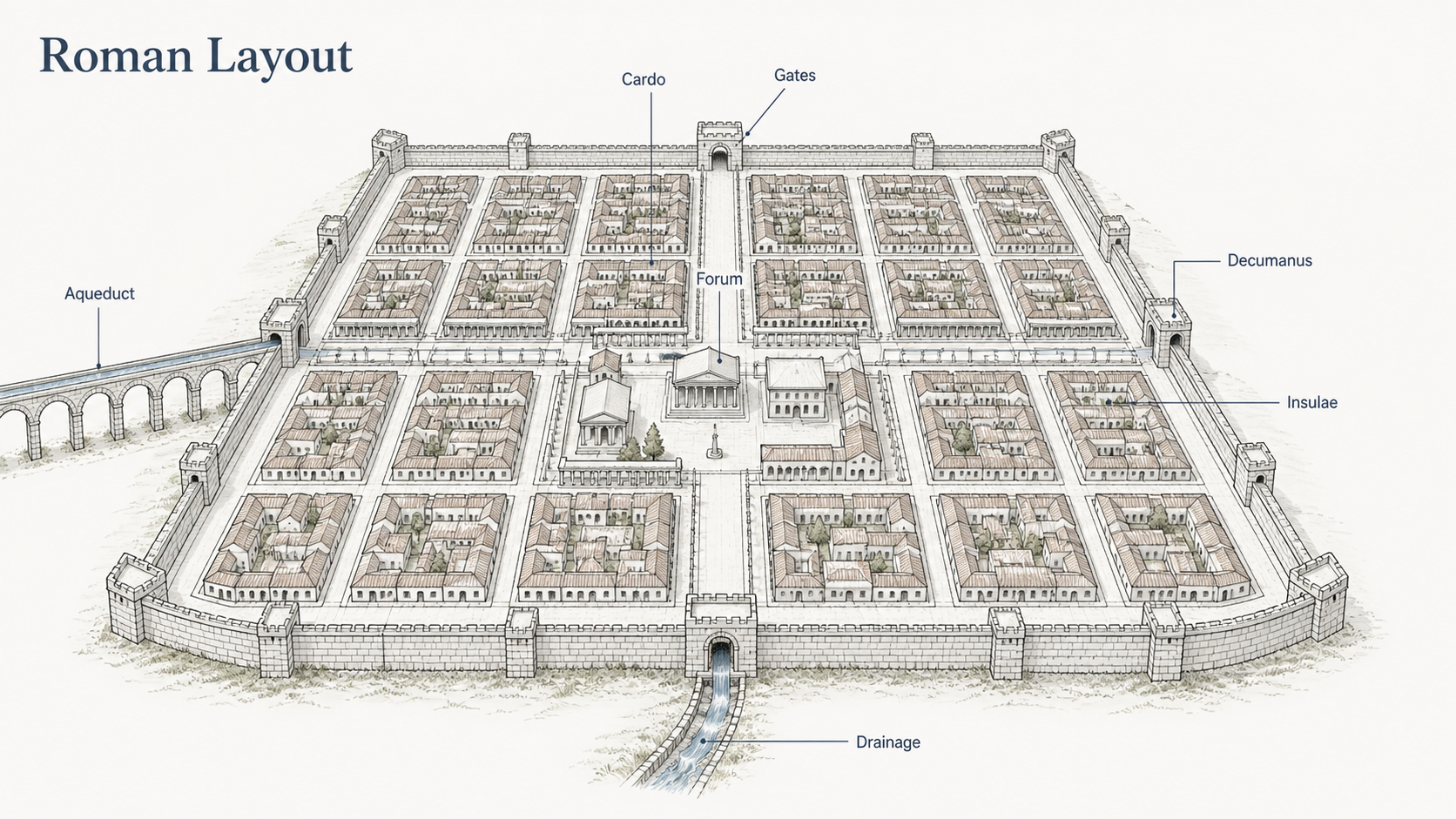
Illustration by ArchitectureCourses.org. Roman urban planning used main street axes, regular blocks, civic space, water supply, drainage, and gates to make the city work.
Walls, gates, towers, and main roads were not separate from the city plan.
Gates controlled who entered. Main streets helped troops and officials move quickly. Straight routes improved visibility and order. In a Roman city, circulation was also authority.
This is easy to miss if the plan is treated as architecture only. The city was a place to live, but also a place to govern.
Where Roman Planning Worked Best
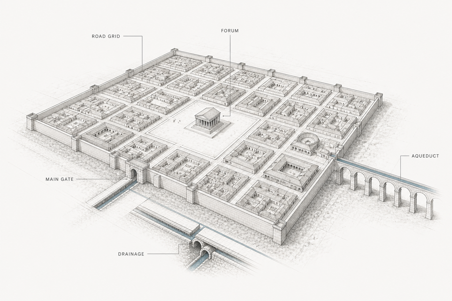
Illustration by ArchitectureCourses.org. Roman planning worked when streets, water, gates, and the forum reinforced each other as one system.
Roman planning worked best when the main systems reinforced each other.
The street grid pulled people toward the forum. The forum anchored public life. Water reached the places where crowds gathered. Gates connected the city to roads beyond the walls. Shops and workshops sat where movement could support them.
Not every city did this perfectly. Terrain interrupted the logic. Older settlements forced compromises. Local customs changed the plan. Money, politics, and military needs changed it again.
The best Roman cities are not perfect templates. They are disciplined compromises.
Pompeii Shows the Messy Version
Pompeii is useful because it is not a perfect diagram.
It had older street patterns, later Roman influence, shops, houses, fountains, baths, theaters, stepping stones, and worn streets. That mess makes it more valuable to study. You can see planning meeting daily life.
The fountains are especially telling. They were not just decorative objects. They were placed where people needed water. The stepping stones were not cute details. They solved a street problem.
Pompeii reminds you that urban planning is not only the big idea. It is also the small adjustment that keeps people moving.
Ostia Antica Feels Like an Urban Machine
Ostia Antica is different.
As Rome's port city, it had to handle trade, storage, housing, worship, baths, administration, and movement. It feels less like a monument and more like a working city.
That makes it useful for students. You can read warehouses, apartment blocks, public buildings, streets, and commercial spaces together. The city does not depend on one famous structure. Its value is in the arrangement.
Timgad Is the Clean Grid Example

Illustration by ArchitectureCourses.org. The forum worked because main streets, civic buildings, shops, and public movement all converged around one central open space.
Timgad, in modern Algeria, is one of the clearest examples of Roman grid planning.
The plan is easy to understand: main axes, blocks, a central forum, public buildings, and an ordered layout. It shows how Rome could establish a city structure quickly in a provincial setting.
Timgad should not be the only Roman model. It is the clean version. Pompeii and Ostia show more of the friction.
Roman vs Greek City Planning
These two traditions get compared constantly and confused almost as often. The difference is not just stylistic. It reflects different ideas about what a city is for and how it should come into existence.
Greek cities usually grew. They followed topography. The agora found its place through use and time. Streets bent around hills, water, and older settlements. The result was cities that felt particular to their place — hard to replicate, shaped by specific conditions.
Roman planned cities were imposed. They started from a standard kit: axes, blocks, forum location, wall perimeter. A Roman military colony could be laid out in days. The same basic structure appeared in Britain, North Africa, Spain, and Syria. That repeatability was the point. You could establish a working city anywhere the empire needed one, quickly, with predictable results.
Neither approach was better. They solved different problems.
| Feature | Greek City Planning | Roman City Planning |
|---|---|---|
| How cities formed | Usually grew organically over time, following topography and settlement patterns | Often imposed from a standard plan, especially in colonies and military settlements |
| Street layout | Irregular in older cities; some later Greek cities used grids, often called Hippodamian planning | Strong grid preference with clear main axes: cardo and decumanus |
| Public center | Agora: a flexible open space for commerce, politics, and social life | Forum: more formalized, enclosed by civic buildings, more hierarchical |
| Relationship to terrain | Built around and into topography — acropolis, hillside theaters, harbor layouts | Often overrode terrain to maintain the grid; adapted when necessary |
| Water infrastructure | Springs, cisterns, and local sources; less systematic than Roman solutions | Aqueducts, fountains, baths, and sewers as integrated city systems |
| Housing density | Mixed, often lower density with courtyard houses as the standard form | Higher density in larger cities; insulae and apartment buildings common |
| Replicability | Low — each city was shaped by its specific site and history | High — the standard colonial plan could be established quickly anywhere |
| What the plan expressed | Civic identity, local democracy, and the particular character of the polis | Imperial authority, administrative control, and military efficiency |
The Hippodamian grid — named for the Greek planner Hippodamus of Miletus — shows that Greeks did use grids in planned cities. Miletus and Priene are good examples. But even there, civic institutions had more flexibility in placement than a Roman forum typically did. The Roman system was tighter, more hierarchical, and more repeatable by design.
When studying Greek planning, start with the agora and work outward. For Roman planning, start with the axes and the forum. The logic runs in different directions.
Where the Roman System Failed
Every planning system has failure modes. Roman urban planning had several, and most came from the gap between the ideal plan and daily life.
Fire. The insulae — multi-story apartment buildings — were Rome's most persistent disaster. They were built fast, often of timber framing with thin party walls, and packed with people using open fires for cooking and heating. The Great Fire of Rome in 64 AD was not a freak event. It was a predictable outcome of dense combustible housing with narrow streets that made firefighting nearly impossible. Augustus created the first fire brigade. It was not enough. Rebuilding rules required more stone and wider streets, but enforcement was inconsistent and the pressure to house more people in less space kept winning.
Traffic. Roman city streets were often too narrow for the volume they were supposed to handle. Julius Caesar banned wheeled vehicles from Rome during daylight hours as a result. Carts arrived at night and created their own chaos. The stepping stones across Pompeian streets suggest streets were regularly hard to cross on foot in certain conditions — not from sophistication but from mess. The cardo and decumanus were wide enough for ceremony and commerce, but the secondary street network often was not.
Sewers. The Cloaca Maxima is famous. What is less discussed is that Roman sewers in most cities were not connected to private housing. They drained streets and public facilities, not individual apartments. Waste from many urban residents went into pots emptied at designated points or into the street. The public system was an impressive engineering achievement that served public buildings and wealthy homes. Ordinary urban residents managed waste in ways the plan did not formally solve.
Forum drift. Forums were designed as civic centers, but commercial pressure was relentless. In many cities, the open civic space gradually filled with shops, stalls, and market activity that pushed out the political and ceremonial functions. The forum that was supposed to express civic power ended up expressing commercial demand instead. Planners kept trying to separate the two functions. The market usually won.
Population outrunning the plan. Planned colonial cities worked well at the scale they were designed for. Rome itself grew far beyond any plan. The irregular organic city around the forums, baths, and monuments was largely unplanned. Insulae filled every available space. The water system was extended repeatedly but always under pressure. A plan handles the founding condition. Growth creates its own logic, and that logic does not always cooperate.
How Terrain Changed the Grid

Illustration by ArchitectureCourses.org. Roman urban planning used simple grids, civic centers, straight streets, and open spaces to make cities easier to organize and use.
The clean grid of Timgad works because Timgad sits on flat terrain with a military rationale behind its layout. Most Roman cities were not Timgad.
Rome itself sits on seven hills. The planned grid could not be imposed on that topography, so the city's major streets followed valleys and ridgelines. The Tiber determined where the port and the commercial districts made sense. The hills determined where defensive walls, temples, and wealthy housing sat. The result was a city that read as Roman in its institutions and public buildings but was fundamentally shaped by terrain.
In hillside cities like Pergamon — earlier Greek, later Roman — and many provincial towns on sloped sites, the main axes bent or terraced. A forum might be cut into a hillside, supported by vaulted substructures. Streets stepped up with ramps and stairs. Water had to be brought in at height so it could distribute by gravity. The grid was a starting assumption, not an absolute rule.
Coastal and river cities introduced another set of problems. Flooding, silting, salt air, and seasonal water level changes all modified what the standard plan could do. Ostia, at the Tiber mouth, dealt with repeated flooding and had to balance port function with civic life. The forum sits inland from the warehouses, which sit close to the water — a practical separation that had nothing to do with ideal planning theory.
The grid was a tool. Terrain, water, older settlement, and military need changed it. The coordination logic stayed constant even when the geometry had to adapt.
Roman Planning vs Modern Planning
The comparison is more uncomfortable than most history courses admit.
Modern cities have better technology, better materials, and better data. They still repeat several Roman failure modes: infrastructure planned separately from public space, housing density outrunning the systems below it, civic centers drifting toward commercial use, and streets sized for the founding condition rather than the city that actually grew.
| Issue | Roman Approach | Modern Equivalent | Lesson Still Relevant? |
|---|---|---|---|
| Integrating water into the city plan | Aqueducts, fountains, and drains designed as part of the city structure | Water and sewer systems often designed separately from streets and public space | Yes — coordination between infrastructure and public realm still fails in many cities |
| Readable public structure | Main axes and forum gave the city a legible center | Many post-war cities lack clear civic centers; people cannot read the plan | Yes — legibility still matters for how people move and gather |
| Dense housing without services | Insulae packed people in without solving fire, sanitation, or access | Tower blocks and dense housing estates with inadequate ground-level services | Yes — density without supporting infrastructure still produces familiar failures |
| Streets as complete systems | Roman streets handled movement, drainage, commerce, and pedestrians together | Modern streets often optimized for one mode, usually cars, at the expense of others | Yes — street design as pure traffic engineering misses the same broader job |
| Civic space under commercial pressure | Forums drifted toward markets despite planning intent | Public squares colonized by outdoor dining, retail, and commercial events | Yes — the tension between civic and commercial use has not gone away |
| Planning for the founding condition | Colonial plans worked at their original scale; growth overwhelmed the system | Master plans designed for one population size struggle when cities grow past projections | Yes — fixed plans and dynamic growth are still in conflict |
| Replicable city templates | Standard colonial plan deployed across the empire regardless of local conditions | Modernist housing and urban templates applied globally without local adaptation | Yes — template planning that ignores local terrain, climate, and culture still fails |
Roman urban planning worked well when the founding conditions held. It struggled when population, commerce, and time pushed past what the original plan assumed. That is not only a Roman problem. It is a planning problem.
Books on Roman Planning and Architecture
The Roman Forum by David Watkin
A strong choice if you want to understand the Forum as a real urban space, not just a collection of ruins. Useful for layout, civic buildings, and how the pieces fit together.
Rome: An Urban History from Antiquity to the Present by Rabun Taylor
Best for seeing Rome as a city across time. Good for readers who want the larger urban story, not only individual monuments.
The Architecture of the Roman Empire: Volume I by William L. MacDonald
Useful for understanding how Roman architecture shaped movement, public space, and civic experience.
Roman Architecture and Urbanism by Fikret Yegül and Diane Favro
A deeper modern reference for Roman architecture, urbanism, public space, and regional variation across the empire.
Daily Life in Ancient Rome by Jérôme Carcopino
Helpful for connecting buildings and streets to how people actually lived, moved, worked, and gathered.
Ten Books on Architecture by Vitruvius
The source text. Not always easy, but important if you want Roman design thinking from inside the tradition.
FAQ
What was the main feature of Roman urban planning?
The grid is what people remember, but the real achievement was coordination — streets, water, civic space, housing, drainage, and commerce forced into one working system rather than planned separately and hoped to connect.
What were the cardo and decumanus?
The main north-south and east-west streets, which typically crossed near the forum and gave the city its primary movement axes.
Why was the forum important?
The forum handled law, trade, public speech, politics, ceremony, and social life. If it was placed well, it pulled the city together. A forum placed badly left the city without a real public center.
Did every Roman city use the same grid?
No. Planned colonies used clear grids, but cities on difficult terrain, older settlements, or organic growth adapted the standard plan considerably.
How did Romans manage water in cities?
Aqueducts brought water in from distances sometimes exceeding 50 kilometers. Once inside the city, it distributed through a hierarchy of channels to public fountains, baths, and wealthy private buildings. Most ordinary residents collected water from street fountains, not household connections. Wastewater left through sewer channels and street drains, but those systems served public buildings and main streets — not individual apartments. The Cloaca Maxima in Rome was impressive. It did not solve the sanitation problem for most of the urban population.
What role did roads play?
Roads shaped where everything else made sense: shops, housing, gates, public buildings, and services all followed the movement they created.
Were Roman cities clean?
No. Not by modern standards.
What can modern planners learn from Roman cities?
Do not treat infrastructure and public life as separate problems. Streets, water, civic space, housing, and trade have to meet in the plan. That is the coordination lesson, and it is still the one most planning gets wrong.
Read Next
Roman Forum Architecture — the civic heart of the Roman city. Covers layout, the buildings around the forum, and how the whole assembly worked as a public center.
Roman Architecture and Engineering — the technical side: vaults, concrete, aqueducts, and how Roman engineering shaped what cities could become.
Ancient Roman Architecture — the broader overview of Roman building types, from temples and basilicas to housing and infrastructure.
Characteristics of Roman Architecture — the specific traits that define Roman building: arches, concrete, scale, and civic ambition.
Roman Colonnades — how colonnaded streets and porticoes structured public space and commercial life in Roman cities.