List of Surveying Instruments for Students and Pros
Surveying Equipment List with Real Field Uses
A survey is only as good as the gear and the person using it. If you work on construction sites, road alignments, pipelines, or boundary work, you need tools that hold calibration, survive weather, and make you faster without guessing. Students need to learn the same gear the field uses.
This guide lays out the core instruments, what they do, the specs that matter, and how different brands stack up. It is written in plain language so you can take it to class or to the site and actually use it.
Complete Guide to Surveying Tools and Their Uses

What Every Surveyor Needs in Their Tool Kit
From total stations to GPS units, here is the real equipment surveyors keep in their kits.
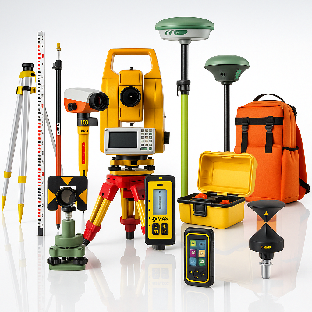
Total Stations
A total station measures angles and distances, then stores or transmits data so you can compute coordinates and elevations. It is the main tool on many modern surveys.
What it does
Set out building corners, curb lines, centerlines, utilities, and control points. Collect topographic points. Check steel and concrete placements.
Key specs to look at
-
Angle accuracy. Common values are 1 arc second for high precision, 2 to 5 arc seconds for general work.
-
Distance accuracy. Typical EDM accuracy is about 2 millimeters plus two parts per million.
-
Range to prism. Often one to three kilometers in clear air with a standard prism.
-
Range without prism. Useful for reflectorless shots on facades and hard to reach points.
-
Compensator. Dual axis tilt correction keeps angles true on uneven ground.
-
Data transfer. Bluetooth, Wi Fi, USB, or controller cable.
-
Battery life. A full day on one or two batteries is the goal.
Pro tips
Warm up the instrument for a few minutes on cold mornings. Check backsight often on days with heat shimmer. Log a redundant check shot every hour so you can catch drift early.
Brand snapshots
-
Trimble S Series. Strong tracking and good with robotics. Cost is high but performance is consistent.
-
Leica TS Series. Very good optics and angle repeatability. Popular with construction layout.
-
Topcon and Sokkia. Reliable and often better value on price. Good battery life.
-
Nikon total stations. Solid for education and small firms.
Quick comparison
| Model class | Angle accuracy | Reflectorless range | Notes |
|---|---|---|---|
| Trimble S7 | 1 to 5 arc sec | about 800 m | Good scanning options and robotic control |
| Leica TS13 | 2 to 5 arc sec | about 500 to 800 m | Fast lock on prisms and clean optics |
| Topcon GM series | 2 to 5 arc sec | about 500 m | Value choice with strong battery life |
Use a total station when line of sight is clear and you want tight control on a site. If you do not have clear line of sight, move to GNSS.
Theodolites
A theodolite measures horizontal and vertical angles. It does not measure distance unless you add tapes or EDM accessories. Many schools still teach with them because the fundamentals matter.
What it does
Traverse work, alignment checks, optical plumbing, and angle only control.
Specs that matter
Angle accuracy. Five to ten arc seconds is common on teaching models. Optical plummet quality. Battery life if electronic.
Pro tips
Keep lenses clean and shaded. Log angles direct and reverse to average out collimation errors.
Brand snapshots
-
Topcon DT series. Durable and simple to use.
-
Leica Builder series. Friendly interface for training.
-
Sokkia DT series. Known for reliability.
A theodolite is fine for learning and for backup, but total stations have replaced it on most production work.
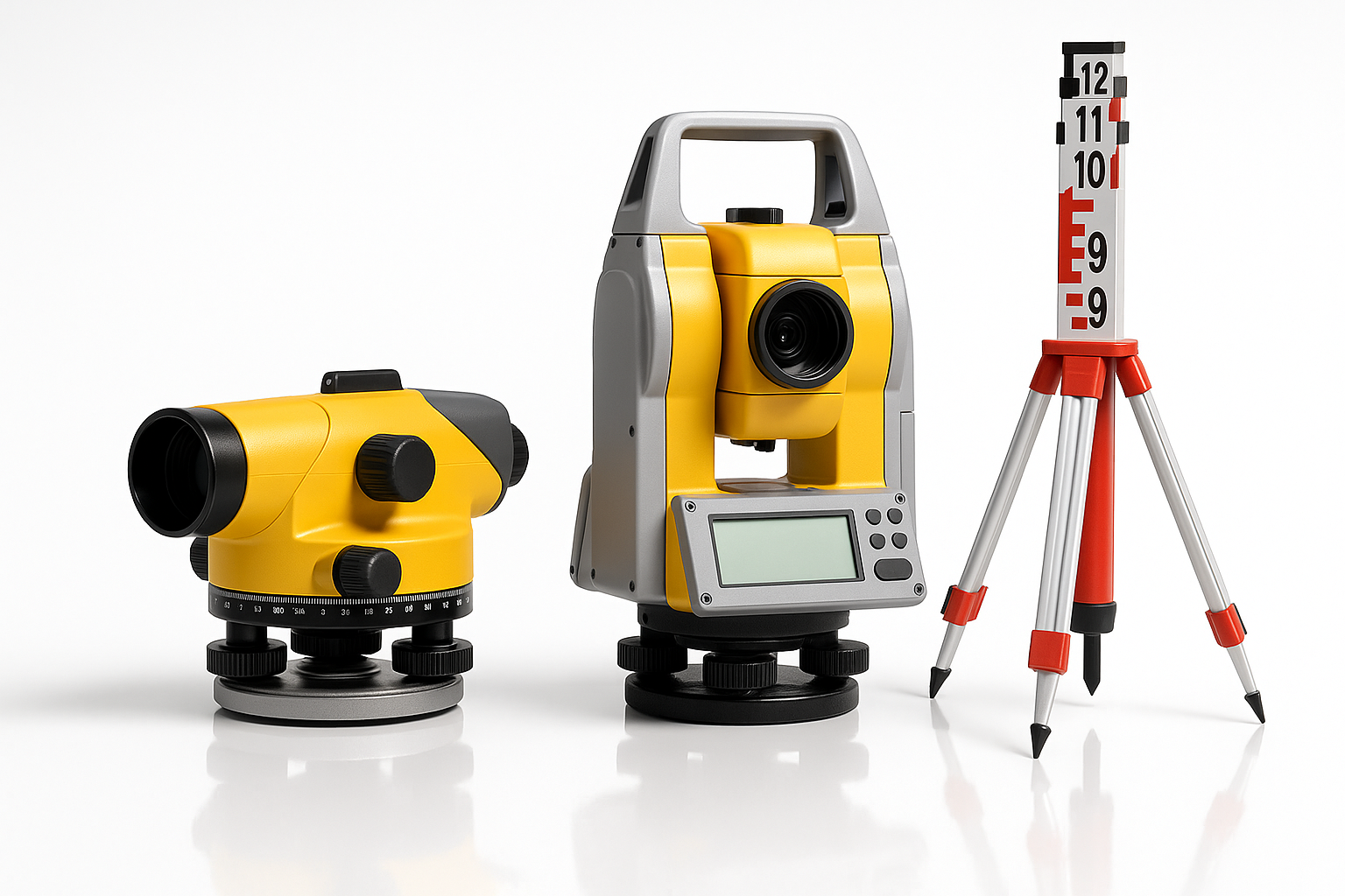
Auto Levels
Also called dumpy levels. These set a true horizontal line so you can read elevations on a staff. Simple. Fast. Trusted for concrete and drainage.
What it does
Check slab heights, set formwork, read cut and fill on grading, confirm slope on drainage lines.
Specs that matter
-
Magnification. Most are 24x to 32x. Higher power helps at longer distances.
-
Accuracy. Think of it as standard deviation per kilometer of double run leveling. Many are around two millimeters per kilometer.
-
Compensator range and damping speed. Good damping settles quickly after wind gusts.
-
IP rating. IP54 or better keeps dust and splashes out.
Pro tips
Always run a quick two peg test at the start of a big leveling job. Keep the staff plumb. Read the central hair to reduce parallax issues.
Brand snapshots
-
Leica NA series. Clear optics and fast focus.
-
Topcon AT B series. Rugged and popular on construction sites.
-
CST Berger and Bosch. Budget friendly and fine for light work.
Comparison
| Model | Magnification | Leveling accuracy | Notes |
|---|---|---|---|
| Leica NA532 | 32x | about 1.6 mm per km | Bright optics and robust build |
| Topcon AT B4A | 24x | about 2.0 mm per km | Good value and weather resistance |
| Bosch GOL 32 | 32x | about 1.6 to 2.0 mm per km | Good for general contractors |
GNSS GPS Surveying Units
GNSS receivers measure positions using satellite signals. With real time corrections they reach centimeter accuracy. Use them when you do not have line of sight over long distances.
What it does
Control networks, topographic mapping, stakeout on large open sites, asset mapping for utilities and farms.
Specs that matter
-
Constellations tracked. GPS, GLONASS, Galileo, BeiDou. More satellites mean better fixes.
-
Corrections. RTK with a base, NTRIP network, or PPP services.
-
Tilt compensation. Sensors that let you hold the rod plumb free and still get accurate points.
-
Initialization time. How fast you get a fixed solution.
-
Radio and cellular options. For rover to base links and NTRIP access.
-
Battery life. A full day on the pole without swaps keeps you productive.
Pro tips
Plan sessions with a satellite chart so you avoid low satellite windows. Keep the antenna area clear of your body and metal. On tree covered sites, save time with topo by TS for tight spots and GNSS for open runs.
Brand snapshots
-
Trimble R series. Very strong RTK and tilt compensation.
-
Leica GS series. Good tilt, smart workflows, and strong support in construction.
-
Topcon HiPer series. Good radio options and base rover kits.
-
Emlid Reach RS2. Budget RTK that works well for education and simple mapping.
Comparison
| Model | Tilt compensation | Corrections | Notes |
|---|---|---|---|
| Trimble R12i | Yes | RTK and network | Excellent in tough multipath |
| Leica GS18 | Yes | RTK and network | Fast tilt and smart workflows |
| Topcon HiPer VR | Yes | RTK and network | Strong radio options |
| Emlid RS2 | Limited | RTK with NTRIP | Good value for training and light jobs |
Use GNSS in open sky. Switch to total station where trees or buildings block satellites.
Laser Levels
Laser levels project a line or a rotating plane. Rotary lasers cover large sites and work hand in hand with grade rods and receivers.
What it does
Pad grading, driveway slopes, formwork, ceiling lines, long fence alignment, drainage fall checks.
Specs that matter
-
Range. With a receiver many rotary units cover up to 500 meters radius.
-
Accuracy. Common values are plus or minus 1.5 millimeters at 30 meters, or around 1 sixteenth inch at 100 feet.
-
IP rating. IP66 or better for real weather.
-
Battery life. A full work week on one charge is ideal.
-
Slope capability. Single slope or dual slope for roads and large pads.
Pro tips
Use a receiver with an audible tone in bright sun. Keep the tripod low in wind. Store it in the hard case and lock the transport mechanism before moving.
Brand snapshots
-
Spectra Precision LL300N. Site tough and simple to run.
-
Topcon RL H5A. Long range and long battery life.
-
Bosch and DeWalt. Good for general construction and interior work.
Comparison
| Model | Accuracy | Range with receiver | Notes |
|---|---|---|---|
| Spectra LL300N | about 1.5 mm at 30 m | about 500 m radius | Strong on grading and concrete |
| Topcon RL H5A | about 1.5 mm at 30 m | about 400 to 600 m | Long run time and reliable |
| Bosch GRL series | about 1.5 to 3 mm at 30 m | shorter ranges | Good for smaller sites and interiors |
Leveling Staff and Grade Rods
These are the bars you read with a level or laser receiver.
What they do
Show elevation changes and grade. Used with auto levels and lasers on nearly every job.
Specs that matter
-
Scale. Feet inches eighths. Feet tenths. Metric. Pick what your jobs use.
-
Length. Collapsed length for transport and extended length for reach.
-
Build. Fiberglass or aluminum. Fiberglass handles weather better.
Pro tips
Keep the rod vertical for true readings. Use a bipod for long shots or windy days.
Brand snapshots
-
Crain SVR fiberglass rods. Tough and easy to read.
-
Seco rods. Widely used with many scale options.
-
Nedo and Sokkia. Good quality and clear markings.
Prism, Prism Pole, and Bipod
A prism reflects the EDM signal back to the total station. The pole positions the prism over a point. The bipod steadies it.
What they do
Stakeout and topo with total stations and robotics.
Specs that matter
-
Prism constant. Match it to the total station settings.
-
Pole scale and locking strength. Solid clamps prevent slips.
-
Bipod leg tips. Good tips hold on hard ground and gravel.
Pro tips
Check pole bubble daily. Paint or label your prism constant on the housing to avoid mismatches.
Brand snapshots
-
Seco and Dutch Hill poles and bipods. Durable and common on sites.
-
Leica and Trimble prisms. High quality and match their instruments well.
Tripods
Your tripod is the foundation for accuracy. Loose legs and worn heads cause real errors.
What it does
Holds levels, total stations, and lasers steady.
Specs that matter
-
Head type. Flat head and dome head. Match your instrument.
-
Material. Wood is stable. Fiberglass handles weather. Aluminum is light but can flex.
-
Clamps. Quick clamps save time. Screws grip well on old legs.
Pro tips
Seat the shoes into firm ground. On concrete use rubber pads. On wind days keep the legs wide and low.
Brand snapshots
-
Seco tripods. Strong and long lasting.
-
Nedo heavy duty models. Good locks and stiffness.
-
CST Berger and Bosch. Fine for light work.
Measuring Tapes and Wheels
Still useful and always in the truck.
What they do
Short checks, offsets, quick layout work, and cross checks for sanity.
Specs that matter
-
Steel or fiberglass blades. Steel is stable. Fiberglass resists moisture and shock.
-
Length. Keep a 30 meter or 100 foot, plus a 50 meter or 300 foot for longer pulls.
Pro tips
Do not yank the hook. Keep the blade clean so numbers do not vanish.
Field Books and Data Collectors
Record what you did so you can defend it later. A field book never runs out of battery. A data collector speeds work and prevents keying mistakes.
What they do
Store angles, distances, codes, and notes. Run stakeout routines and COGO.
Specs that matter
-
Screen visibility in sun.
-
Battery life for a full day.
-
Rugged rating such as IP65 or better.
-
Software that matches your office workflow.
Brand snapshots
-
Trimble TSC series. Common with Trimble instruments.
-
Leica CS series. Tight integration with Leica gear.
-
Topcon FC series. Good battery life and bright screens.
-
Panasonic and Juniper rugged tablets. Run vendor software and CAD.
Pro tips
Sync data every day. Keep a paper sketch of control and backsight for every setup.
Safety Gear
High visibility vests, hard hats, safety glasses, hearing protection, gloves, and boots with good tread. Add sun sleeves and water for hot sites. The best survey is the one you finish without injury.
Accessory List That Saves Time
-
Mini prisms for tight corners and short offsets
-
Optical or laser plummets for fast setups
-
Tribrachs with optical plummet and quick release adapters
-
Grade stakes and carpenter pencils with bright paint
-
Sun shade for instrument on hot days
-
Small torpedo level and wrench kit
Surveying Gear You Can’t Skip
Some tools are nice to have. These you simply cannot work without:
● Tripod and Tribrach – A total station without a stable tripod is useless.
● Prism Pole – The other half of every total station shot.
● Field Controller – For data entry, coding points, and quick checks.
● Backup Batteries – One dead battery can shut down a full crew.
● Level Bubble – A $10 part that prevents $10,000 mistakes.
And What You Can Work Without (Most Days)
● Sunshade for controller – Nice in summer, but not critical.
● Pole bipod – Handy, but you can manage without if you’re careful.
● Fancy carrying case – Any rugged pack will do if you’re organized.
How to Pick the Right Tool for the Job
Building layout on a tight site
Total station with a prism and good tripods. Laser level for slab and interior.
Large open topo
GNSS with RTK and a data collector. Total station for check shots and under trees.
Road and drainage work
Laser level with slope function. Auto level for checks. Grade rods marked in tenths.
Boundary retracement
Total station and theodolite knowledge for angles. GNSS for control ties where legal and suitable. Field book notes are critical.
Small contractor jobs
Laser level for pads and drains. Auto level for quick checks. A compact total station if layout gets complex.
Common Mistakes and How to Avoid Them
-
Skipping backsight checks. Do a quick check at every setup.
-
Setting tripods on soft soil without stomping feet. Push legs down to refusal.
-
Using a receiver on high speed rotation indoors. Slow the head so you can see the beam.
-
Storing gear wet. Dry cases and instruments before closing the lid.
-
Relying on one tool only. Mix GNSS and total station so you can keep moving when conditions change.
Brand Strategy by Budget
Student budget
Used auto level, used theodolite, fiberglass rod, light tripod, tape, and a simple data collector app on a rugged phone or tablet. Learn fundamentals before chasing high end gear.
Small contractor budget
Rotary laser with receiver, auto level, sturdy tripod, tenths rod, and a starter total station if you do layout often.
Survey firm budget
Robotic total station, base rover GNSS kit with network corrections, several tripods and prisms, rugged data collectors, and backup levels. Add scanning options if you do as built work on complex sites.
Side by Side Summary Tables
Surveying Instruments List for Construction and Land Work
Must-Have Surveying Tools and How They Work
Total stations
| Use case | Best choice | Why |
|---|---|---|
| High accuracy building control | Trimble S7 or Leica TS high accuracy | Strong angle precision and tracking |
| General construction layout | Topcon GM series | Good value and battery life |
| Education and training | Nikon or Sokkia entry models | Lower cost and simple menus |
GNSS
| Use case | Best choice | Why |
|---|---|---|
| Urban and tree cover mix | Trimble R12i or Leica GS18 | Tilt and strong multipath handling |
| Open farmland and utilities | Topcon HiPer | Good radio range and battery life |
| Student training and mapping | Emlid RS2 | Affordable RTK learning platform |
Auto levels
| Use case | Best choice | Why |
|---|---|---|
| Concrete crews | Leica NA532 | Bright optics and fast focus |
| General contractors | Topcon AT B4A | Rugged and accurate enough |
| Budget setups | Bosch GOL 32 | Good cost to performance |
Rotary lasers
| Use case | Best choice | Why |
|---|---|---|
| Large grading sites | Spectra LL300N | Site tough and accurate |
| Long days without charging | Topcon RL H5A | Very long battery life |
| Interior and small sites | Bosch GRL series | Easy to use indoors |
Workflow That Prevents Rework
-
Start with control. Check known points or set your own with redundancy.
-
Warm up instruments. Optics and electronics stabilize after a few minutes.
-
Calibrate checks. Quick two peg for levels. Backsight checks for total stations. Fix status on GNSS.
-
Log everything twice. Digital file and a field book sketch.
-
Move in a loop. End where you started so you can close the loop and see error.
-
Back in the office, run adjustments and flag outliers before you issue results.
Final Advice
Buy the best tripod and rod you can. A strong base makes every instrument better. Keep gear clean. Store it dry. Calibrate on a schedule. Mix tools so you are never stuck by trees, traffic, or weather. Learn the old methods so you can spot when a fancy screen is lying to you.
A good survey kit is not about one brand or one shiny instrument. It is a system that matches your work. If you are a student, master the basics and ask to shadow crews. If you run a firm, invest in instruments that cut setup time and survive abuse. If you build things, pick the tool that makes your layout fast and repeatable. The right equipment lets you measure once and build with confidence.
FAQs
50 Surveying Equipment FAQs
General Basics (Beginner Level)
1. What is the difference between a total station and a theodolite?
A theodolite only measures horizontal and vertical angles. A total station does that plus distance measurement using EDM (Electronic Distance Measurement). With a total station you can store data, calculate coordinates, and connect to GNSS. For example, a Leica TS07 can measure 1.5 km to a single prism. A classic Wild Heerbrugg theodolite needs a tape or chain for distances.
2. Do surveyors still use tape measures?
Yes. On a drainage project last month we still used a 50 m fiberglass tape to measure offset distances for stakes. Tapes are quick, don’t need power, and are perfect for short cross-checks when accuracy within ±2 mm is fine.
3. How accurate is a typical auto level?
Site-grade models like the Topcon AT-B4 give ±2 mm over 1 km double-run. Higher-grade like the Sokkia B20 can achieve ±0.7 mm. For most construction leveling that’s more than enough.
4. Can I do a full survey with just a laser level?
No. A rotary laser will set level and slope, but it won’t give you coordinates, angles, or mapping. It’s great for slab pours and grading, but you’ll still need a total station or GNSS for full layouts.
5. Is surveying equipment weatherproof?
Most pro gear is IP54 to IP67 rated. A Spectra LL500 (IP66) will handle driving rain, but a basic Bosch GLL2 (IP54) should be kept under cover in heavy weather.
6. How often should I calibrate my level?
Check every week if in daily use. Formal calibration at least once a year. On big jobs, we check against a benchmark at the start of every day — that’s how you catch drift early.
7. Can surveying be done at night?
Yes. We’ve set control lines at 2 a.m. on quiet roads. You’ll need lighted reticles and reflective prisms. GNSS has no daylight requirement.
8. Is GNSS the same as GPS?
No. GPS is the U.S. system. GNSS means all constellations: GPS, GLONASS, Galileo, BeiDou. A Trimble R12i uses them all for faster fixes.
9. Why do surveyors carry a field book if they have data collectors?
Electronics fail. A paper field book will outlast a dead battery or corrupted file. On one bridge job, our collector locked up for half a day — the paper notes saved us.
10. What is “backsight” in surveying?
It’s measuring to a known point to verify your instrument setup. Skip it and you risk your entire traverse being wrong.
Total Stations
11. What is the best angle accuracy for a building site?
1" to 3" (arc seconds) is overkill for most construction. A 5" unit like the Topcon ES-105 is plenty for general layout.
12. How far can a total station shoot without a prism?
Reflectorless range varies. A Trimble S5 can hit 800 m on white targets. Cheaper units may top out at 300 m.
13. Do robotic total stations need two people?
No. A Leica TS16 or Topcon GT can track a prism and be operated by one person using a field controller.
14. Can I use any brand prism with my total station?
Yes, but set the prism constant in your instrument. Leica prisms often have a -34 mm constant, while Seco is typically 0 mm.
15. How long do total station batteries last?
6–8 hours on a single charge. We always carry two spares per instrument to avoid downtime.
16. Does heat affect total station readings?
Yes. On a 45°C road site, we saw EDM readings drift 4 mm over 500 m due to heat shimmer. Early morning shots fixed it.
17. Can I run a total station in freezing weather?
Yes. We’ve worked at -15°C with a Topcon OS-103, but you must keep batteries warm inside your jacket.
18. What’s the difference between 1” and 5” total stations?
It’s angular precision. 1" is used for control networks and high-precision alignment. 5" is fine for formwork, grading, and building layouts.
19. How do I check if my total station is level?
Check the electronic bubble and confirm with the circular bubble. If they disagree, you need service.
20. Can total stations be repaired on site?
You can swap batteries, clean lenses, and adjust tribrachs. Full calibration needs a service lab.
GNSS and GPS
21. What is RTK in GNSS surveying?
Real Time Kinematic. It uses corrections from a base station to give centimeter-level results. Without RTK, you’re stuck at meter-level.
22. How much open sky do I need for GNSS to work well?
Aim for clear sky above 15° elevation. Urban canyons and trees slow fixes.
23. Does GNSS work under trees?
With a Trimble R12i or Leica GS18T, yes — but fixes take longer and may need more satellites.
24. How accurate is GNSS without RTK?
Standalone is ±3 m. SBAS (WAAS/EGNOS) gives ±1 m.
25. Can I use a phone for surveying?
Phones can map trails or boundaries to a few meters, but they can’t replace professional GNSS for legal surveys.
26. Do I need a base station for GNSS?
For RTK, yes — unless you pay for a network correction service.
27. How long does it take to get a fixed RTK solution?
A good setup locks in under 10 seconds in open sky.
28. What happens if I lose radio link to the base?
You’ll drop to float accuracy until reconnection. Some systems “bridge” short dropouts with predictive algorithms.
29. Is tilt compensation worth it?
Yes. With a Leica GS18T, we’ve saved minutes per shot by skipping the bubble check.
30. How long do GNSS rover batteries last?
8–12 hours depending on temperature and satellite tracking mode.
Levels and Lasers
31. What’s the main use of an auto level?
To establish elevation differences. Still the fastest tool for setting batter boards and checking forms.
32. How far can a rotary laser project?
Up to 500 m radius with a receiver. The Spectra GL622N can run dual slopes at that range.
33. Can a laser level replace an auto level?
For grading and paving, yes. For millimeter-accurate leveling over long runs, no.
34. How do I check if my laser level is still accurate?
Do a two-peg test: mark two points, rotate the laser, re-check, and compare readings.
35. Are green lasers better than red?
Green shows up better in daylight. The trade-off is shorter battery life.
36. Can I use a laser level in rain?
Yes, if IP-rated like IP66.
37. How do slope lasers work?
They tilt the laser beam to a set percentage for drainage and road grades.
38. What’s the lifespan of a good laser level?
With care, 5–10 years. We still use a Spectra LL500 bought in 2012.
39. Do I need a tripod for a laser level?
Yes for most outdoor jobs. Indoors, wall mounts or clamps can work.
40. Can I use a laser level at night?
Yes. Beam visibility improves in darkness.
Field Practices and Care
41. How should I store surveying instruments?
Dry, in a case, with foam supports. Remove batteries for long storage.
42. How often should I clean lenses?
Only when dirty. Use air blower and lens tissue — never rub grit directly.
43. Can I fly with surveying equipment?
Yes. Carry delicate items onboard. Tripods and rods go in checked baggage.
44. What’s the biggest cause of bad data?
Skipping checks — especially ignoring backsight readings.
45. Should I log measurements twice?
Yes. Electronic plus handwritten is standard best practice.
46. How do I secure gear on site?
Never leave it in plain sight. We’ve had gear stolen while staking lines.
47. What’s the life expectancy of a tripod?
5–15 years. Fiberglass lasts longer than wood in wet climates.
48. Can rain damage my instrument?
Yes if water gets inside optics. Always dry gear fully before storage.
49. What’s the best way to transport tripods?
Tie legs together, carry with head up, and avoid banging the tips.
50. Do I need insurance for surveying equipment?
Yes. A stolen robotic total station can cost $20,000 to replace.
Related
- How the Spectra LL300N-1 Laser Level Holds Up in the Field
- Best Rotary Laser Level for Contractors and Big Projects
- Is a $30,000 Foundation Repair Worth It? What You Need to Know